Italy is an overwhelming place to plan a trip to. At least, that was my experience. Every time I thought about going to Italy, I found myself overwhelmed by the number of “must visit” cities. For a country the size of Florida and Georgia combined, I always felt similarly to how I imagine tourists trying to plan a visit to the vast United States must feel - so many historical sites, so many different food regions, so many areas of unique natural beauty. There’s no way to see it all in one trip, unless you have an unlimited timeline.
But something kept drawing me to one area of Italy in particular, a place as far North as you can go before you’re in Austria - the Dolomites.
For two years in a row, I was signed up for a trail running tour group that would traverse the trails of the Dolomites and the lakes of Slovenia. And for two years in a row, the injury prone runner that I am, I couldn’t run. I had lost thousands of dollars, but after two years of disappointment I was still determined to see the spiky, jagged peaks of the stunning Dolomite Mountains. If I couldn’t run, I could hike.
The problem was, I had gone from having a fully-planned, guided vacation on the calendar and now I suddenly had two-weeks to fill with a self-created itinerary.
I love trip planning, but at times this felt like I may have bit off more than I could chew as I navigated websites not only in Italian, but German, as many of the regions in the Dolomites are German-speaking (in fact, 64% of people in the Northern Dolomites speak German as their primary language).
On top of all of that, I would be doing part 1 of the vacation totally solo AND without a car. I will admit, I was more nervous than I let on, especially to my parents, who were nervous enough themselves.
The algorithm kept bringing me to Italian pick-pocket TikTok, and I found myself terrified that I would be standing out as a solo female traveler somewhere I didn’t speak the language. That coupled with the fact that I had an ambitious itinerary with multiple locations, ferries, trains, etc., had me spending hours researching every single detail.
The good news is now you don’t have to! Instead of going into in-depth explanations on each and every step of this trip, I’ll link to some of the best resources that helped me, and can help you too!

DAY ONE - VENICE
I landed in Venice at 9:35 AM and had spent so much time stressing and researching the best way to get from the airport into the actual city of Venice. Here are two articles that will help you make the decision that’s best for you from Welcome Pickups and A Bontempo Abroad.
I opted for the Alilaguna “water bus” because I liked the idea of arriving to Venice via water and because it was more affordable than a private water taxi. Plus, my hotel had a very convenient map on its “Getting Here” section which showed the walking path right from the St. Mark’s ferry stop to the hotel.
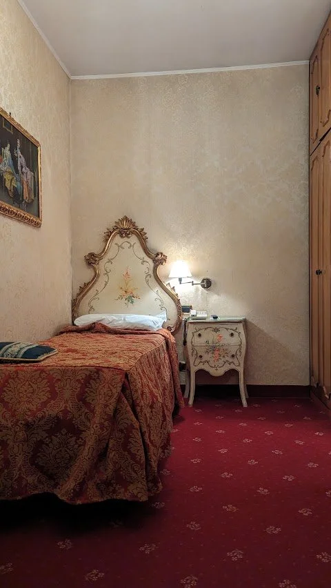
I was able to check in pretty quickly after dragging myself and my luggage through the absolutely packed St. Mark’s Square. Venice is an expensive city, and not exactly cost-effective for solo travelers looking for lodging in a central location. I found out the hard way that going on the cheap can have consequences - I ended up with pretty terrible bed bugs and have no problem calling out the hotel that did absolutely nothing to remedy the situation so that you can avoid the same fate - DO NOT stay at Hotel Antico Panada! A quick review of Google reviews will show that since I stayed, there are TONS of guests reiterating the fact that there are bed bugs in this hotel.
It genuinely put a huge damper on my trip. The bites were massive, itchy, painful and I was up every night going down Reddit rabbit holes of people spending thousands of dollars to rid themselves of bed bugs. I was terrified to bring them back to my apartment. Each hotel I would get to, I would comb through my clothes and suitcase. It was awful.
Anyway. When I first checked in, I was blissfully unaware of the insect ordeal heading my way. I firmly believe that the only way to combat jet lag is to power through your arrival day sans nap and that is what I did. I headed out into maze-like streets of Venice with a vague idea of where I was headed - Libreria Acqua Alta - a unique bookstore that uses boats, bathtubs, and other buoyant containers as bookshelves.

Whether this is a kitschy gimmick or a necessity based on the local doesn’t really matter. It’s enormously popular, to the point that visitors need to walk in a predetermined path along the stores’ shelves, and pay up a few euro to take a photo in the gondola tied outside the window (I may sound judgmental here but rest assured, I stood in line for my photo).

I meandered and took photos of every bridge and canal I crossed - there are a LOT and couldn’t help but laugh each time I came to a dead-end that was just water. It was fascinating to think about this city being created. I also loved watching all the gondoliers - they are seriously skilled. I saw three at the same time in one teeeeeny, narrow canal. They use the sides of the buildings to push off with their legs. It’s nuts! Full body workout.

Next on the agenda was gelato, obviously. I joined the long queue for Suso gelato. There was a girl from Boston behind me also traveling solo and we chatted for a bit. I got pistachio and it was delicious!

Wandered some more until it was time for dinner at Trattoria Gazzettino. Honestly, I wasn’t blown away but I feel like the first night dinner on a trip is always hit or miss as you get your bearings. The staff were nice and gave little complimentary things like some risotto to try and a sampler of desserts at the end. And their bread basket was great! But my meal of linguine with scallops and mushrooms was just OK. I felt like it was drowning in oil and there weren’t a ton of scallops. It cost 32 euro, with a glass of the house red.
After dinner on my way back to the hotel, I stopped in San Marco Square and looked around, took some cool shots of the reflection of Doge’s and then I was under the impression that St. Mark’s Campanile closed at 7 PM per Google but I passed it and the last entry was 8:45 PM!
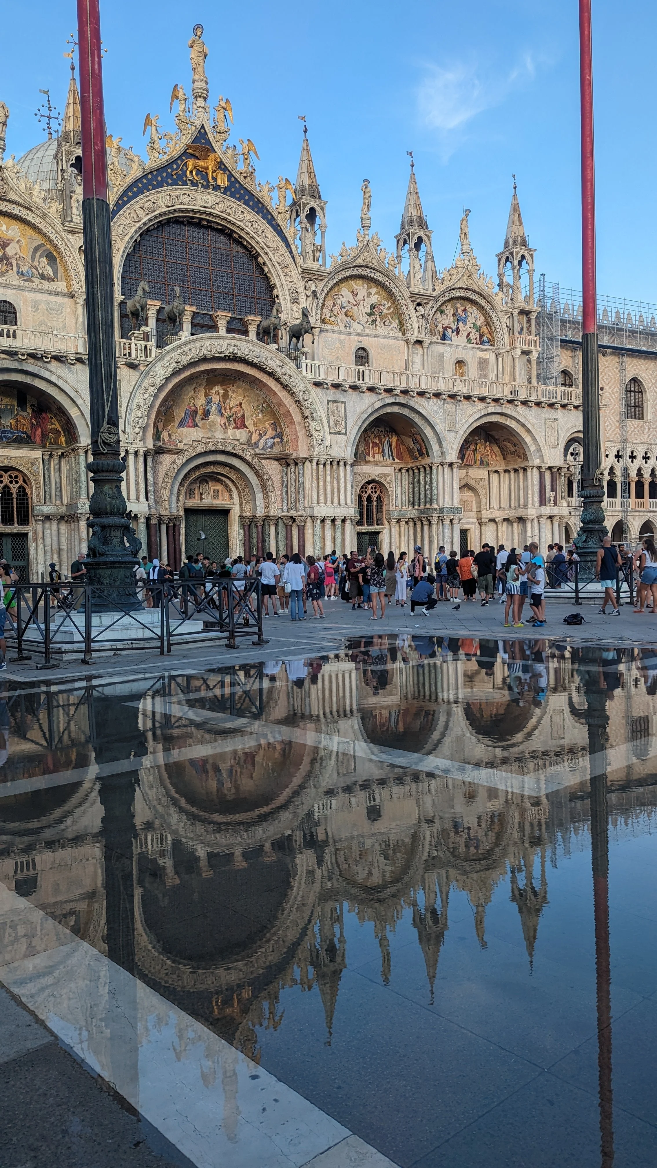
I went in at 7:20 and the views were beautiful - it costs 10E but when you think of the the price for something like the Empire State Building - it’s fair! I wish I wasn’t so tired and didn’t have to pee so badly because I would have loved to have stuck it out for sunset - I’m sure it’s gorgeous!

I was bummed that you needed to pay $3 to download the app to be told what all the points of interest were around the panoramic views but I wouldn’t be bothered with downloading, paying, etc. so I just took in the golden hour vibes and made my way back to the hotel for bed.
DAY TWO - VENICE
Day two in Venice I was up and out early for a walking tour booked through Airbnb Experiences.
On the way to the tour, I walked over the Rialto Bridge, overlooking the Grand Canal and it was so quiet and peaceful! The city was juuuust waking up and I enjoyed a solitary moment in this spot that would later be teeming with people.

The tour was good, not great - our guide, Clementine, was very sweet but very all over the place. And the woman on the tour with me was…not my favorite.
Regardless, we went over by an hour! So I go a three hour tour + my first Italian breakfast of a cappuccino and pistachio creme filled croissant.
Some random things that I remember from the tour:
-The fancy doors and fronts of the building are on the water side
-Don’t eat fish out on Monday - it’s not fresh (it’s from Saturday because the market is closed on Sunday).
-The islands all serve different purposes. There’s even a trash island!
-Burano is the most instagrammable place - Murano is more industrial with the glass factories
-There’s something like 600 unique columns on St. Mark’s Bascilica
-The piece of wood that the oar rests on each gondola is specific to the gondolier
-Learned a bit about the foundations of the buildings here - everything is crooked and leaning but designed so if it collapses it would collapse inward
-They’re really anti air-conditioning - they think it’s bad for you, and the environment (the shutters are their climate control).
-Cannoli should be refrigerated or it’s not real!
Some of my tour guides recs were:
Marchini Time
Al Merca
Casa del Parmigiano
Cantina Do Spade
Carina Do Mori
All Arco
After the tour I wandered over the “Wooden Bridge” and wanted to do some souvenir shopping along the way but it was a really fancy area and I wasn’t in the market for a Louis Vuitton bag.
Next up was one of the highlights of Venice for me- a rowing class with Row Venice! It was such a better use of 85 Euro.
To do a 30 minute gondola ride will cost you 80-100 euro. OR you could spend 85 Euro for 90 minutes learning the Venetian style of standing rowing in a batele with an all woman owned and operated organization! No brainer.
Rowing was tons of fun and easier than I thought! Of course I was delighted that my instructor said she loved how natural I looked! Steering/rowing from the back of the batele was WAY harder though, and my left shoulder was screaming!
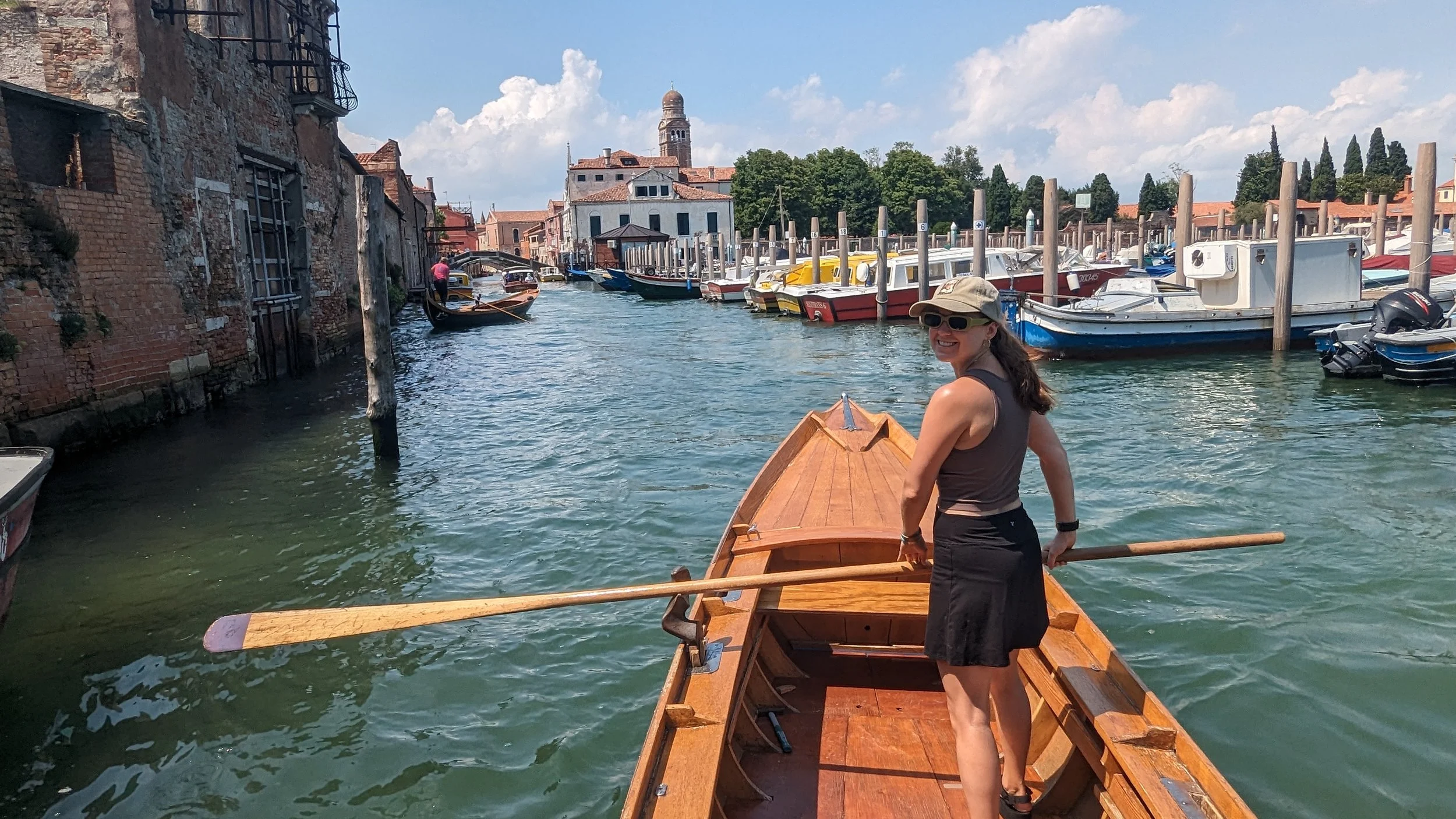
The 90 minutes flew by even though I was worried the small talk was going to be awkward, since it was just me and the instructor, but it wasn’t at all!
We covered a random variety of topics, including an explanation on gelato types. The fruity gelato is sugar, the creamy ones use milk, and the chocolate, vanilla and coffee are egg based! I guess a lot of people in Italy are lactose intolerant and can really only eat parmegiano! (Which checks out, my tour guide Clementine was FULL of dairy slander!)
It was such a cute little area where we were rowing and when we finished I went to get a cappuccino gelato at the spot my guide had recommended. I liked it better than Suso, but it melted so quickly in the sun!
After refueling I wandered over to the Dorsuduro area - I wish I hadn’t followed so many main streets but it was quickest (and the most crowded). Along the way I shopped for some Murano earrings and finally settled on two pairs.
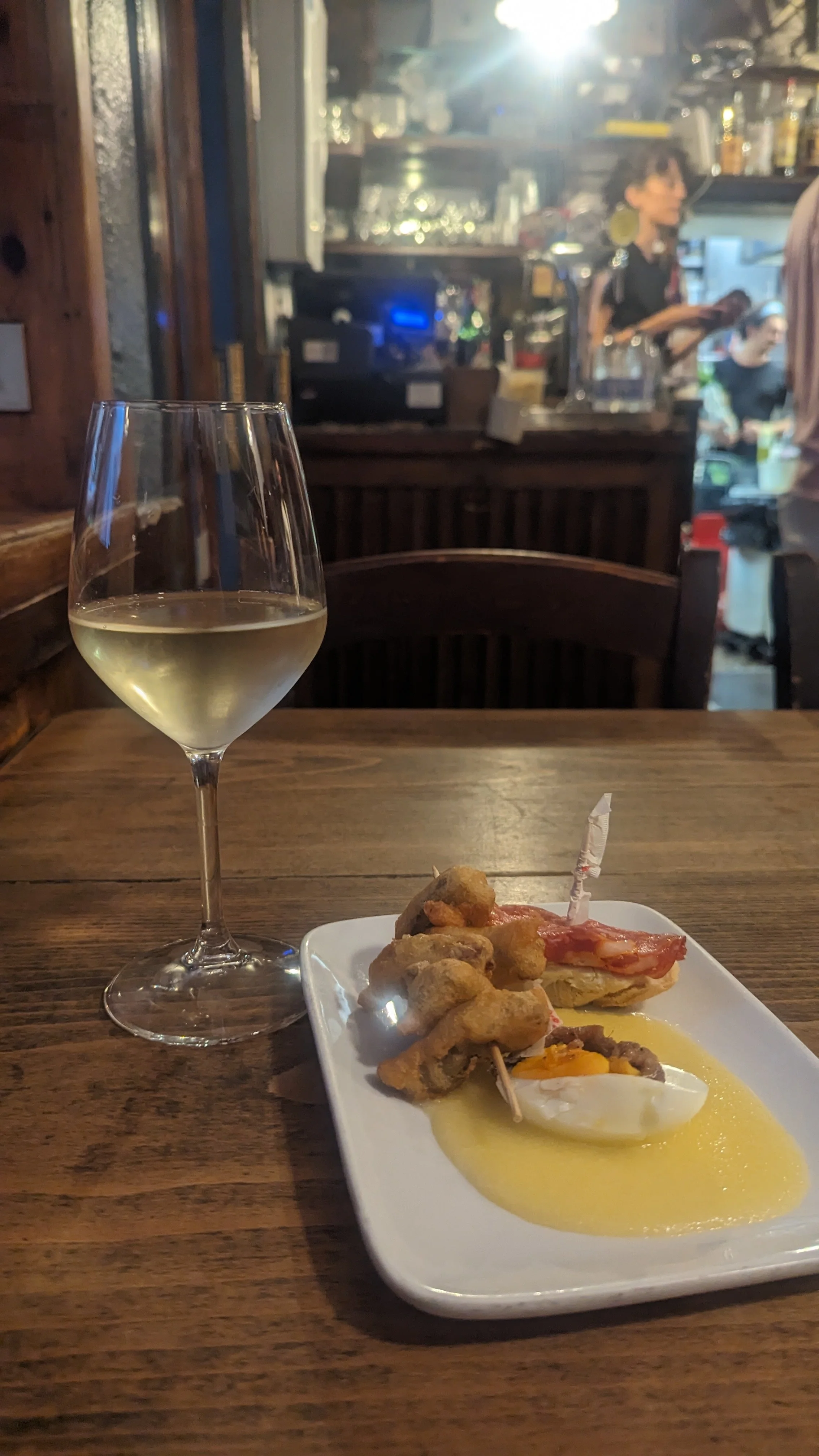
I dropped things off at the hotel and changed and then I thought I would stop at St. Mark’s Bascilica because I thought there was a 5:30 mass but it wasn’t until 6:45. So I wandered off to the Cantina Do Spade (two swords) and there were already a few people sitting outside waiting for it to open! We were all American and chatted a bit. One couple did a day trip to Cortina D’Ampezzo yesterday and said it was much cooler and that everything was written in Italian, German and English - PHEW!
When the clock struck 6 we walked in and I ordered a white wine and some pinchetti - the half egg with anchovy that Clementine had told us to order (served over polenta), a piece of bread with meat/cheese and fried artichoke. The polenta was by far my favorite part. The place was bumping and I journaled a bit and then with a bit of a wine blur made my way back to the church.
The security guard turned people away but let me in when I said I was there for mass. Then I felt guilty only staying for a few minutes so I settled in (I was actually fully dripping in sweat with my shoulders covered with a scarf).
I’m glad I stayed - the priest even gave a bit of a sermon in English and I was surprised at how many parts I picked up. Plus the little kids choir sounded beautiful and I was actually stunned and had mini chills looking up at the vast quantity of small gold mosaic tiles that make up the domes of that church. Unreal - I don’t get how it was ever finished!!

After church it was time for PIZZA. I went to 1000 Gourmet which sounds like it should be awful but I read it was some of the best in Venice. The dough was amazing, but overall the food here didn’t really do it for me.
My overall though leaving Venice was that as a New Yorker, we’re always saying “nothing is easy” - but Venetians may just have us beat!
DAY THREE - BOLOGNA
After a subpar hotel breakfast in Venice (I cannot find one good thing to say about this place…) I navigated myself to the “bus” (a ferry) to the train station where I bought my ticket to Bologna and boarded a very lovely, clean, well outlet-ed train (the LIRR could never).
The hotel I was staying at in Bologna (Hotel Il Guercino) was very close to the train station. Sadly, it was still early and my room wasn’t ready so I dropped my luggage in the storage room and headed out to walk the Portico and the Sanctuary of San Luca.
Mo Mortadella lab
Bologna is known as a foodie town in Italy - and to be known as a foodie town in Italy of all places, means the food is really damn good. Some people say Bologna is in fact Italy’s best food city! This put a lot of pressure on the 2 meals I would be eating here.
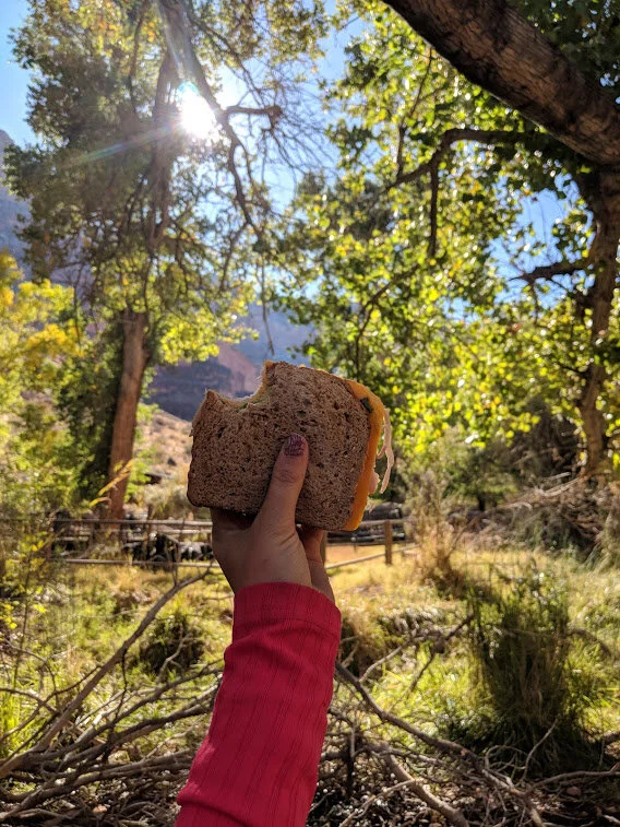
A friend had told me that a must-eat while in Bologna was a sandwich from Mo Mortadella Lab and knowing I had a long, steep walk ahead of me to the Sanctuary of San Luca, it was the perfect place to stop and be prepared for a “summit” sandwich.
I ordered the #2 which had mortadella, mozzarella, tomatoes and arugula. So simple, yet so good. The bread was so fluffy and fresh. The mortadella was divine (I now order mortadella whenever I see it on a menu). The layer of cheese was thin and not at all overwhelming. And my god I finally had that classic Italian moment you always read about where you taste a tomato and it’s like you’re eating one for the first time! I was legit closing my eyes, humming, happy dancing - while sitting on a bench with picturesque rolling hills in the background and the city down below. There was a brief moment where I thought I might save the other half for later, but that sandwich didn’t stand a chance. And for 9 euro! A STEAL.

Needless to say, Mo Mortadella Lab gets my full endorsement!
WALK THE PORTICO TO THE SANCTUARY OF SAN LUCA

One thing about me is that even in a city - I’m going to find a way to hike up a hill and eat a sandwich. Lucky for me, Bologna has a very well known urban hike that showcases some seriously historic architecture as you traverse the world’s longest portico (4 KM long) that has been around since the 1400s.
The route brings you through the hills outside Bologna and up to the Sanctuary of the Madonna of San Luca.
Walking the portico route was honestly so great because it was SUNNY and HOT but being able to be in the shade 90% of the time made a huge difference.
At a certain point, the “hike” truly begins and it is definitely an uphill climb - for around 1.3 miles. I booked it, I was hot, tired and hungry and just wanted to be at the top! The views were gorgeous, and it was a very well deserved summit sandwich at the time.
I had been chugging water the whole way up and was happy to find that there were bathrooms at the top (be prepared with a few coins to pay!)
In my planning I found a few great step by step guides to completing this walk - complete with pictures!
INSTAGRAM WORTHY STOP

I had saved this location in my offline map of Bologna so that I could stop by and snap a photo - I gotta admit, it was worth it! When I arrived, there was no one there, but by the time I had finished taking a peak at the canal, there was a small line starting to form.
DINNER AT TRATTORIA DA ME
After finally checking into the hotel and taking a quick shower, I walked another 30 minutes to my 7:30 PM dinner reservation, right when the restaurant opened. There was already a huge line!
It’s popular for a reason. My meal was phenomenal. I started with Lambrusco - a sparkling red wine that was super refreshing, followed by the “slow cooked egg” in a gazpacho with fried cheese. It was great, though the award for best gazpacho still goes to my friend Abby’s mom!
My entree was the ravioli (tiny little guys) filled with cheese that was sooo creamy, salty and amazing. It was served with crumbled sausage and a pea sauce. WOW. Had I been with my friends, I would have been mmm-ing and ahh-ing over it, but that would have seemed super weird for a solo diner so I kept the noises to myself.

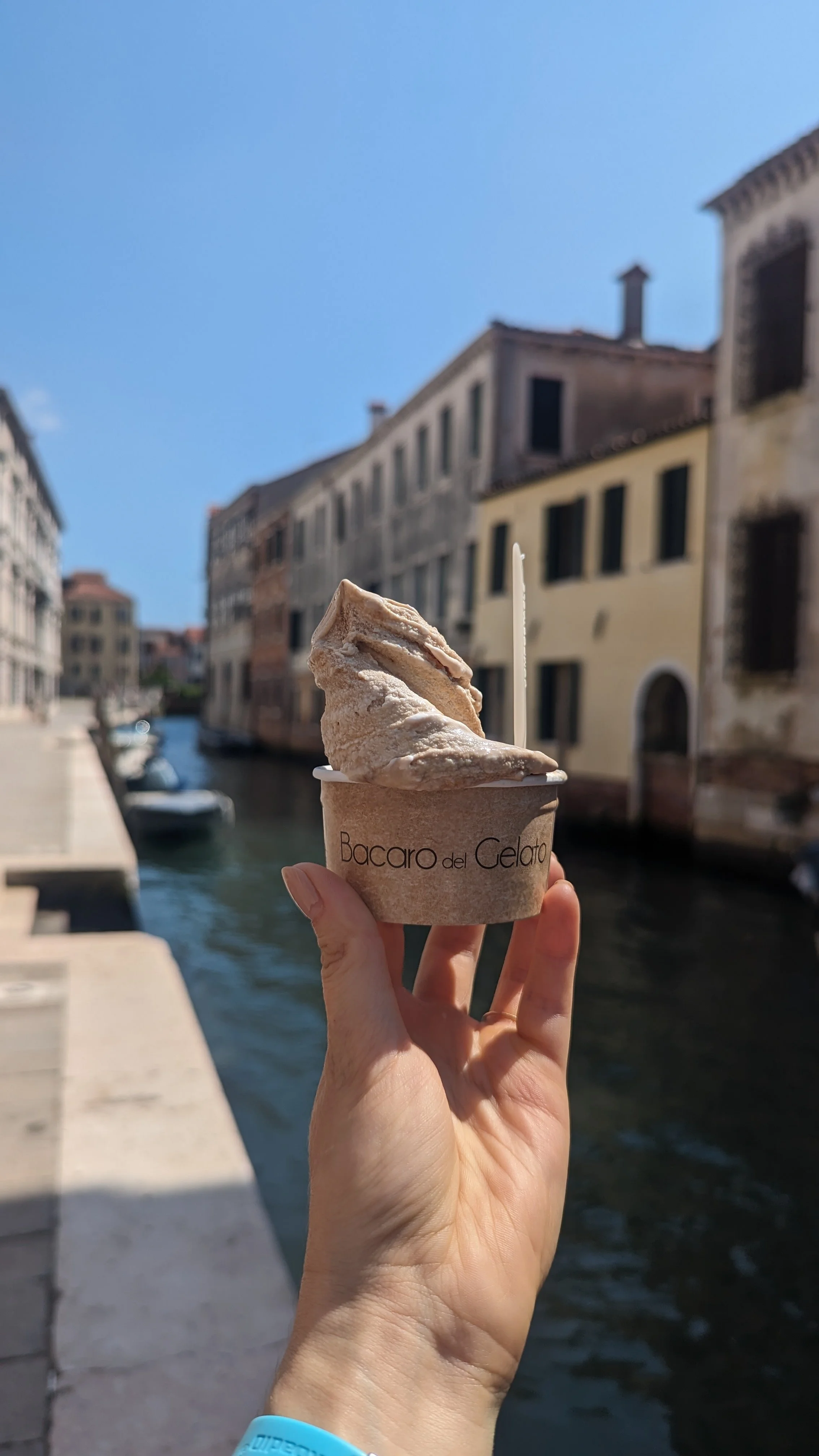
I walked back to my hotel and stopped on the way for a stracciatella gelato - 3 days, 3 gelatos, 3 flavors.
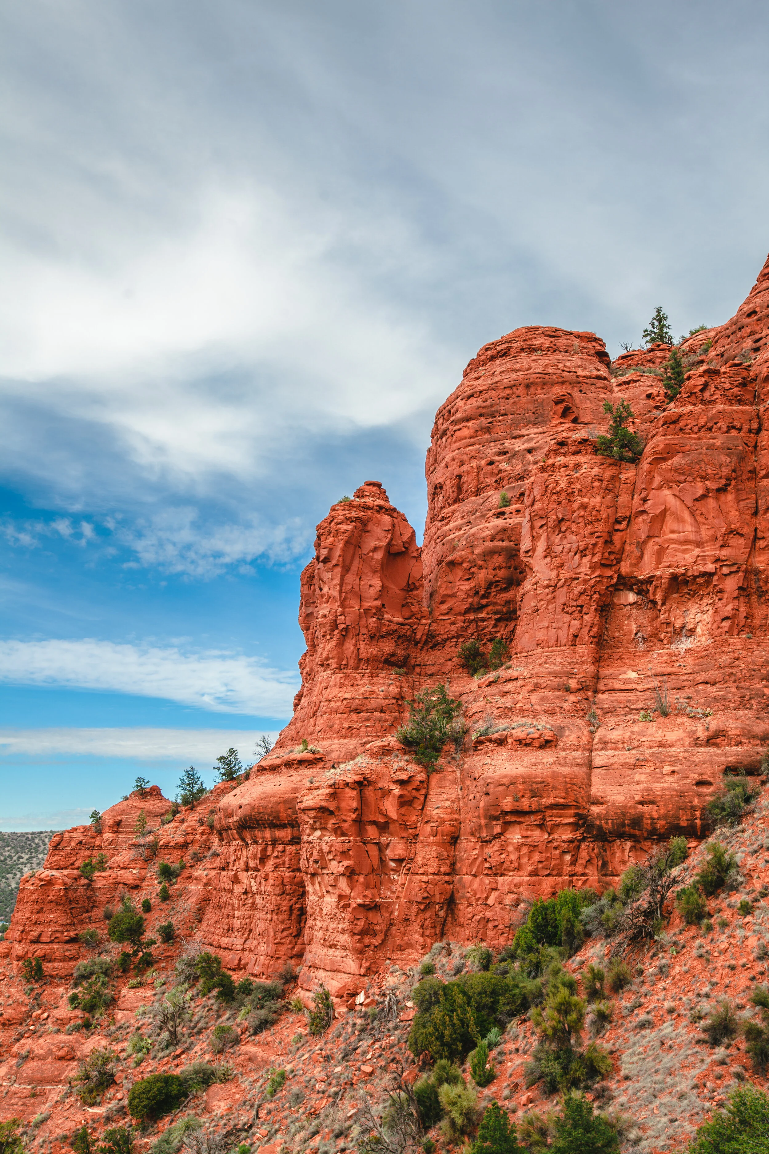
DAY FOUR - FLORENCE
Tip: When you arrive at the train station - get some biscotti from Cantucci Lory. Deliziosa!
Shop for a leather jacket
My day trip to Florence had one main goal - purchasing myself a leather jacket. I had so much fun wandering in and out of the endless leather shops. I had a list of places that had been vouched for by friends and the internet and I also just went on vibes.
The owners in these shops were characters, let me tell you. They really gassed me up, telling me I had “the mannequin figure.” Every jacket I tried on was “perfect” - they wanted to FaceTime my parents to convince me to get the jackets.
It was really interesting to me that it seems like certain leather shops have regional clientele. When I went into Massimo’s, he guessed that I was from Long Island and lived on the Upper East Side…incredibly specific. He showed me his log of where his customers were from, and it was definitely a theme!
Here are some of the shops I had researched / came recommended to me:
Da Vinci Leather (this is where I ended up getting my jacket!)
It was so fun giving myself permission to splurge and pick something out that I really wanted and it makes me happy to this day every time I put my leather jacket on!

ALL’ANTICO VINAOI
Ok, this might be an Instagram spot, but it IS pretty damn delicious.
My initial plan was to visit Pino’s Sandwiches panini shop since there are now multiple All’Antico Vinaoi’s in New York City, but unfortunately it was closed for the summer.
So I joined the throngs in line for All’Antico Vinaoi. They have 4 difference windows so the line moved really fast but I was shocked at how many people plopped down right on the street’s tiny sidewalks to eat their sandwiches. It was giving Times Square red stairs and I wanted better ~atmosphere for my sandwich eating.

So I walked up to Piazzale Michelangelo, passing Ponte Vecchio along the way (hard to photograph, but definitely beautiful) but it was HOT and fully in the sun. So I wandered down a little and found some shade with a view of the top of the cathedral to eat my sandwich. It was delicious (I ordered the La Favolosa (Salame toscana, pecorino cream, artichoke cream, spicy eggplant, with sundried tomatoes) but I felt incredibly hot and could only eat like 1/4 of it.

go for a walking tour
My walking tour was just OK, so I won’t necessarily suggest it, but I do think a walking tour in general is always a good idea.
When I got my first view of the cathedral, my jaw dropped. It is so massive and stunning. I think even if I lived there, I wouldn’t get used to the size of it!

One thing I noticed while in Florence - the sidewalks are SO narrow. One of the “things to do” is get a drink from one of the “wine windows” but while it might make for a cool photo opp, the actual drinking experience didn’t seem that great to me. Instead, I went into one of the places with a wine window (Babae) and sat down in a CHAIR to drink my Aperol Spritz. Call me crazy!
I finished the day in Florence with a chocolate gelato from Venchi in the train station that was UNREAL. I think it ended up being my favorite gelato of the trip (lucky for me - Venchi is also in NYC).
DAY FIVE - BOLOGNA TO BOLZANO
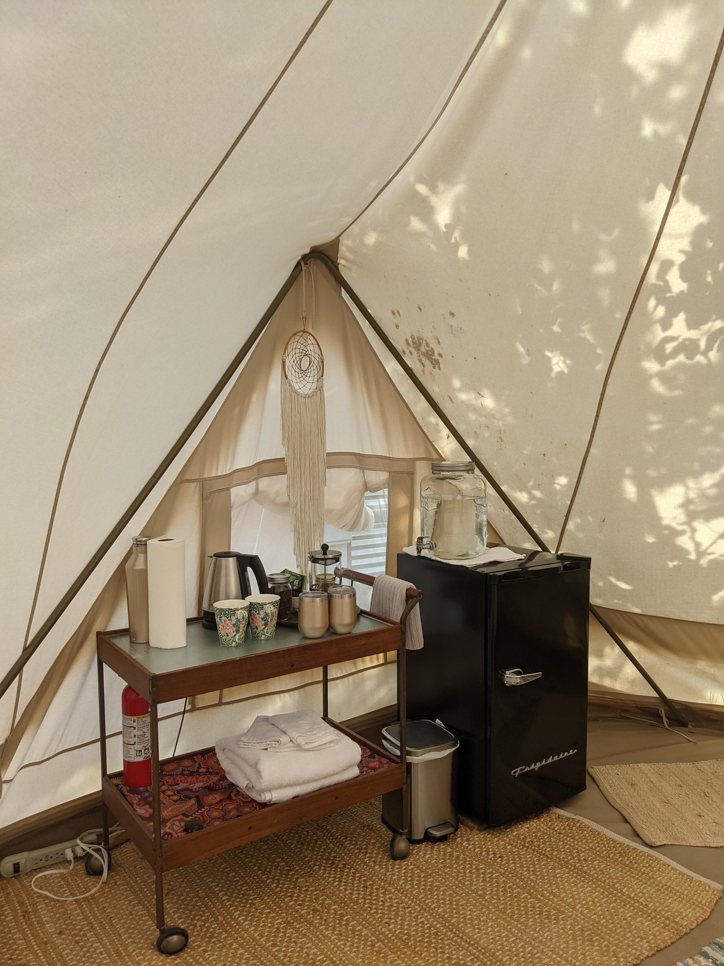
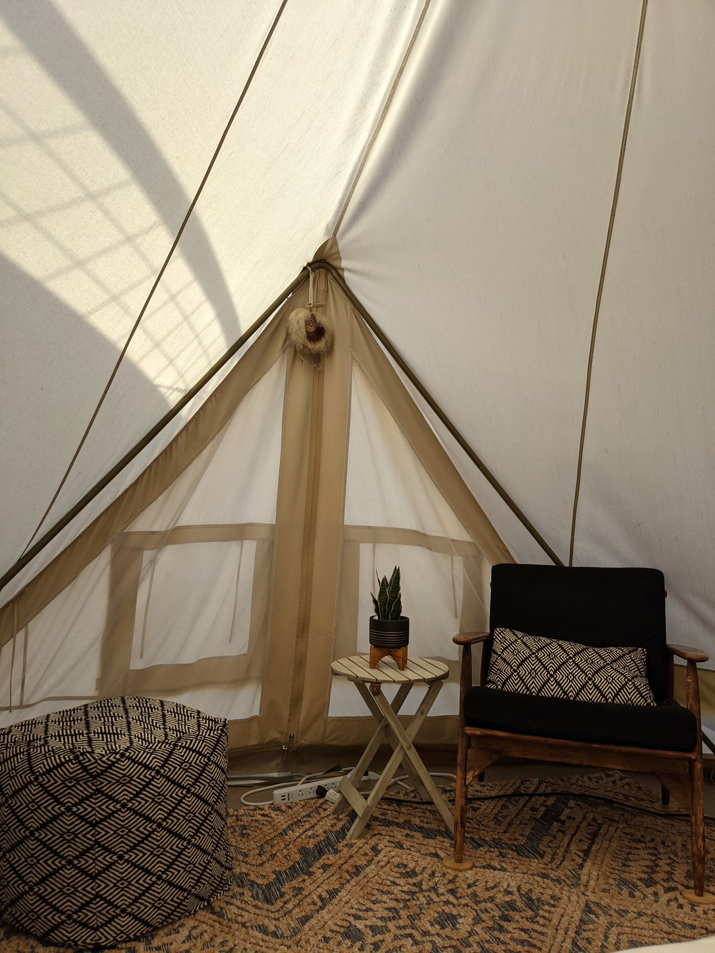
The train from Bologna to Bolzano was a breeze, and I even figured out the transfer from the Bolzano station to Bolzano Sud, which was closer to my hotel. Check-in was easy since I was staying at a chain hotel. I took a nap, worked out at the hotel gym, and read outside on the balcony before a hotel dinner.
It was a nice reset day before the outdoorsy portion of the trip started!
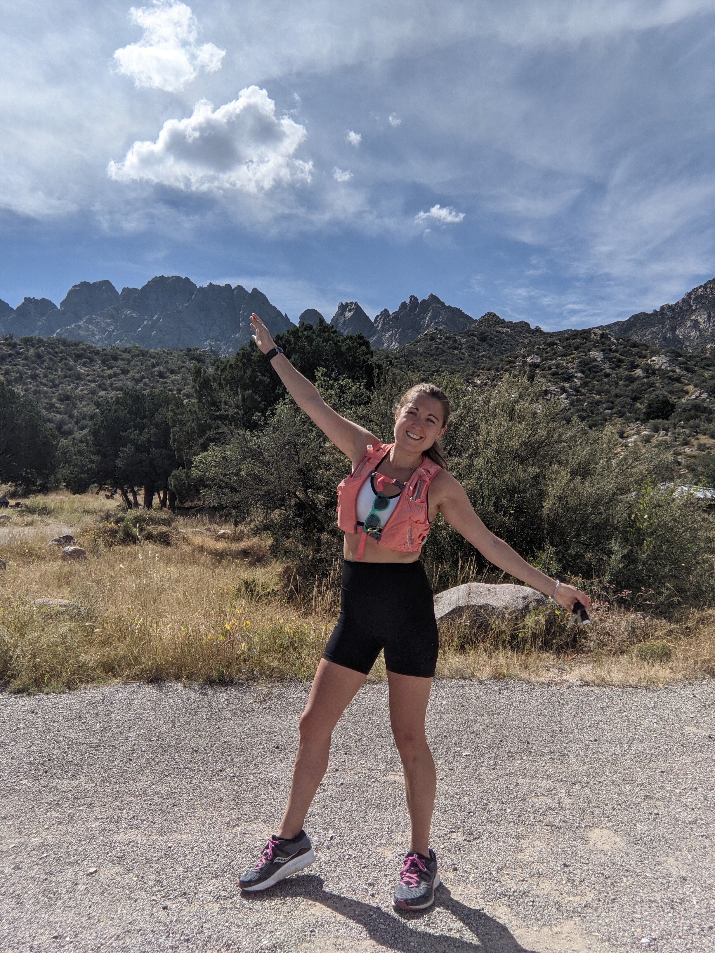
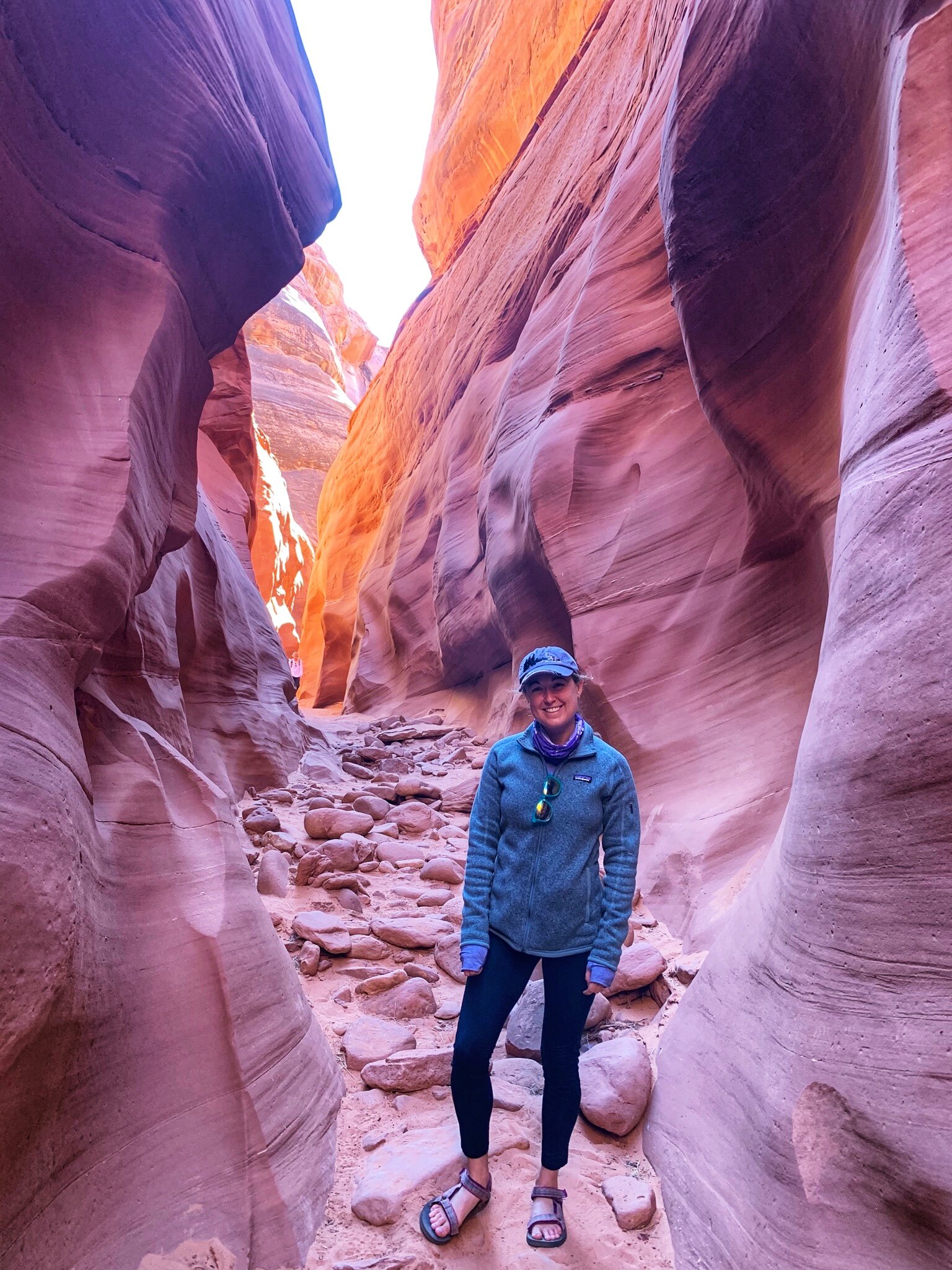
DAY SIX - SECEDA
Before I start diving into the portion of my trip where I explored the absolutely stunning Dolomites, I need to call out Moon Honey Travel - the blog that single handedly made this trip possible with their incredibly detailed information on the Dolomites and specifically, visiting the Dolomites without a car. If you’re interested in taking a trip to the Dolomites you without a doubt need to check out their blog.
I started Day 6 taking the train from Bolzano Sud to to Bolzano, a short 7 minute train ride to the main train station. Once there, I went to the bus ticket office and purchased a round trip ticket and found the 350 bus to Ortisei (this website will help with train/bus planning prior to your trip!)
The bus ride was slightly terrifying - completely blind turns up the mountains. I felt like we came close to hitting so many cars!
I had printed off pages from a blog showing pictures of how to find your way off the bus to the cable car once I arrived in Ortisei, and it was super helpful. I went up the escalator, up the moving sidewalk, and purchased a “return ticket to the top” - first was a small gondola car up to the middle station before switching to a huge gondola car that carries about 30 people which took us allllll the way up to Seceda.
Here’s the hike I did from Moon Honey Travel: Seceda – Rifugio Firenze Circuit Trail, Dolomites

The views were immediately jaw dropping. I don’t think I’ve ever taken so many photos on a hike but sadly, the weather meant the photos didn’t do it any justice. I did get a few moments of blue skies, but at least there were no storms or rain even if I was fully in the clouds with zero visibility at some points during the day.
The first hut I stopped at (the Pieralongia Hut) and had some yogurt with jam and wow - definitely the best morning yogurt views I’ve ever had, but I was also just really excited to have some yogurt at that point since all I’d had was some instant coffee and a pack of dried mango.

The most amazing thing about the scenery was that the valley was SOOOO GREEN in contrast to the crazy, craggy, rocky peaks jutting up around me.
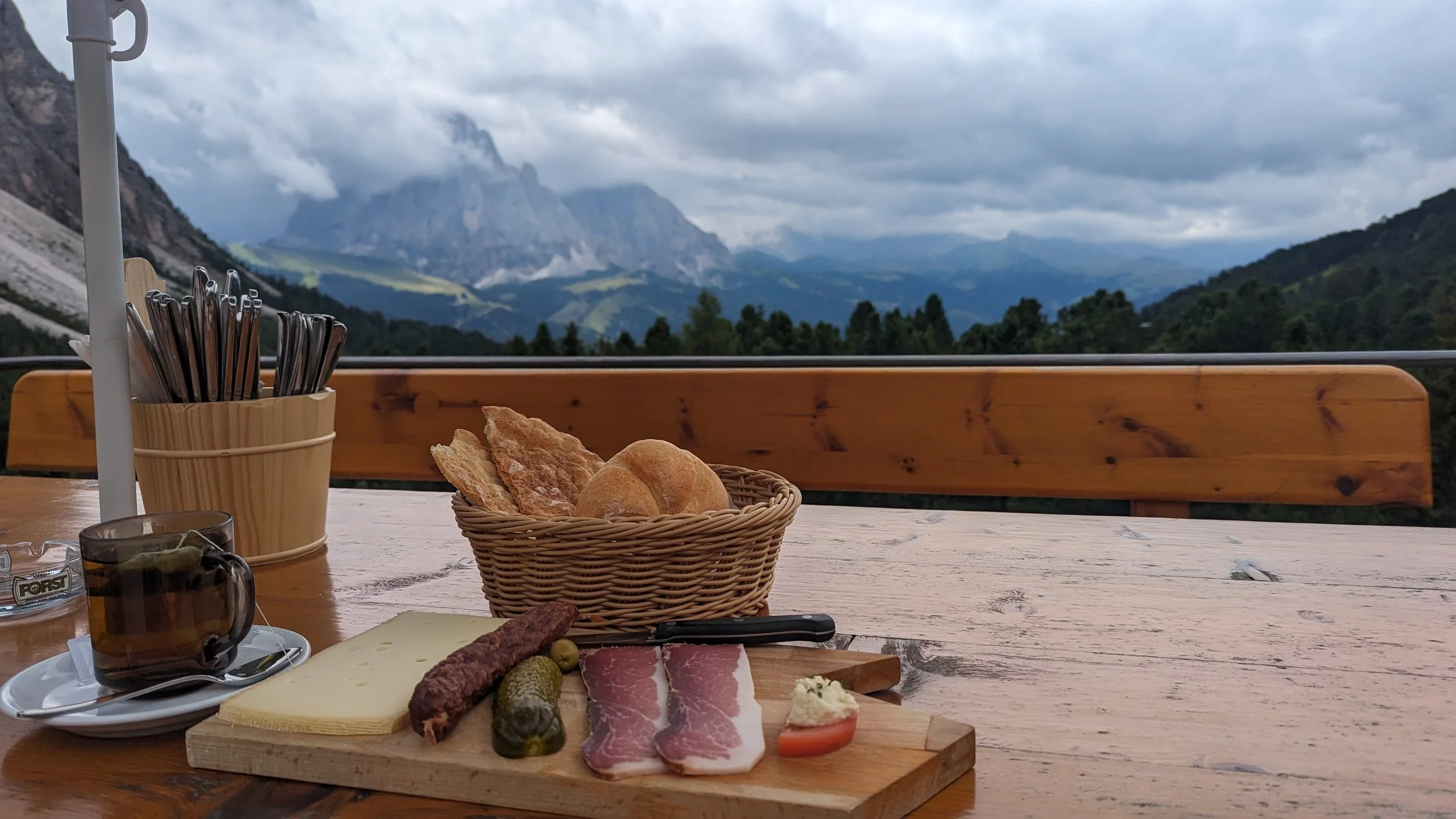
By the time I made it to Rifugio Firenze/Ragensburger Hutte it was just opening up and I snagged a great table. I started with a macchiato, then got a mint tea and the “Hut Board” which came with meat, cheese and bread. All so fresh. I ate half then made little mini sandwiches to eat later along the journey. I was sad because since it was only a 6 mile hike, I was halfway done at this point.
After this stop, the uphill started and some points were STEEP MAN! I was finally sweating but kept my long sleeve on, I was SHOCKED at how cold it was for August (in the 50s!) I was also shocked at how little English I heard being spoken but whenever I did, I asked for a picture (and one girl saw me struggling with self time and saved me). Oh also, the cows! They got so close to you and were not bothered by humans at all. They wore bells and the whole time I was wondering if the cows hate them, and are sick of the noise they make wherever they go.
Halfway up I stopped at Sofia Hutte and again just sat and watched. Got a few more moments of bright sun and blue skies but then just as quickly clouds would come and engulf everything.

I took the cable car down at the end of the hike and talked to two nice families from Seattle and Holland. When I got back down to Ortisei, I realized it was SUCH a cute little town. I wandered around the San Antonioplatz area a bit, waiting for the next bus and sadly my gelato plans were foiled by a summer camp with like 20 children ordering in front of me and I eventually abandoned my mission for fear of missing the bus.

The 350 pulled up and I’m glad I asked the driver because it was NOT going to Bolzano. I recognized a trio that I had taken the bus with in the morning getting on and stopped them. The right bus came a few minutes later and at that point I was sweating and BURNING in the sun - such a different temperature down off the mountain!

When I got back into town, I took a stroll to the Bolzano grocery store and the woman at the cash register was so cute speaking English to me and apologizing that her English wasn’t great and she didn’t know her numbers. I was saying grazie and danke and feeling like the dumb one. It’s so impressive how many different languages people speak - and I didn’t get the feeling that they were annoyed by English speakers which definitely isn’t the case everywhere.
Then I hopped on the short train ride back to Bolzano Sud (the train station closer to my hotel) and had dinner - salad, tuna, cookies, trail mix).
DAY SEVEN - ALPE DI SIUSI
We have come to the point in the journey where I either stopped journaling or just can’t seem to find my journal / notes on my phone to recount this part of the trip. Unfortunately for you, you’ll be reading about the rest of the trip from my memory, which would be OK if I hadn’t waited nearly 2 years to finally write this trip recap.
For the Alpe Di Siusi hike, it was a last minute decision to go. I was tired and the weather wasn’t great so I had already decided I wasn’t going to do the Adolf Munkel Weg hike that was originally on my itinerary since the trip to the trailhead was more complicated. But I figured I could mentally handle the same journey to Ortisei and start a different hike from there. Lucky for me, Alpe di Siusi is one of the sunniest places in the Dolomites (around 300 days of sun a year!) and what appeared to be a cloudy day ended up being completely wonderful. I was so glad I put in the effort of going back to Ortisei.

For Alpe di Siusi you take another lovely gondola ride to start your hike. I ended up doing an 8 mile hike with 1,101 ft. of elevation gain. It was so beautiful and I stopped for so many photos. Alpe di Siusi (Seiser Alm in German) is an alpine meadow filled with various hotels and refuges. It would be an incredible place to stay for a few nights to go on a different trail run every morning. It’s also a great place to bike and obviously, ski in the winter. It is mind boggling to me that this is what ski-life is like in Europe. As a northeastern girl that grew up skiing in Vermont, I was amazed at how enjoyable skiing out west was. Imagining skiing in the Dolomites, it’s brain melting.


This time when I got back to Ortisei, I made sure to successfully get gelato.

Osteria Dai Carrettai di Sartori Stefano
Back in Bolzano, I went to a cute little wine bar that serves a variety of bruschetta and mini bruschetta. I got myself a glass of white wine and some small bites and enjoyed the atmosphere.

DAY EIGHT - BOLZANO “REST” DAY
By rest day I mean I didn’t go for a hike - but I did wake up and go to the hotel gym to do some strength. Then I walked around a cloudy Bolzano and waited in line to get in to see the local celebrity…
South Tyrol Archeological Museum
The local celebrity is Ötzi the Ice Man. And Ötzi is a glacier mummy from the Copper Age who was discovered by hikers in 1991. He was almost perfectly preserved. When was the Copper Age, you might be wondering? A casual 5,300 years ago.
It was a really interesting museum and seeing the mummy was wild. Definitely glad that I went, even though museums aren’t necessarily my travel jam.
After the museum, it was time to do something wild - meet up with a high school friend and her girlfriend who just HAPPENED to also be in Bolzano. Let’s be honest - when you hear people are visiting Italy, they’re usually not talking about Bolzano, so this coincidence felt really crazy. We both live in NYC, but hadn’t seen each other in years. We met up at Osteria dai Carettai di Sartori Stefano and caught up and it was great! I probably talked way too much after being alone for a week.

When they left for their next destination, I headed to dinner.
Cavallino Bianco
This place had great reviews online. I’ll lift the Google description: Meaty Tyrolean specialties, plus pasta & Italian wines, in a rustic, long-standing Alpine tavern.
I had a super hearty dish of beef and poltena while I read my kindle. After the taste of conversation and camaraderie with my friend that afternoon, I was beyond excited to finally meet up with Sam the following day!

DAY NINE - BOLZANO TO VERONA TO TO CORTINA D’AMPEZZO
If you couldn’t tell by the heading, this was quite the day.
First, I took a train to Verona where I stored my luggage in the station. Then, I went directly to the meeting spot for a walking tour with Free Tour Verona.

Since my notes are gone, any facts I learned about Verona are, sadly, also gone.
After the walking tour, it was time to find Sam! After parking the rental car, I immediately made Sam walk up a big hill to a scenic overlook. We passed on the massive line to see “Juliet’s balcony” and around 4:30/5 PM started our journey to a brewery that Sam had found and wanted to check out.


It was absolutely adorable! And a beautiful night to sit outside. The only problem was it was around 7 when we arrived and 8:30 PM when we left. And Sam was unaware that we were still 2-3 hours from our final destination. And not just 2 hours of highway driving… 2 hours of pitch black, blind curve, terrifying mountain driving on little sleep. This is what Sam and I call an “oopsie poopsie!”
There were moments that I was both laughing and crying at the same time because I was absolutely terrified, but also this was so classic Lauren and Sam that I really had to laugh!
We made it safely to Hotel Villa Argentina, eventually!
DAY 10 - LAGO DI BRAIES
During our treacherous drive from Verona to the Cortina D’Ampezzo area, it was pitch black and we weren’t exactly taking in any views.
Waking up in the morning, it felt like Christmas! I could see the mountains and I felt so energized just from the sight of them. We thoroughly enjoyed breakfast - nothing better than a hotel breakfast buffet - except a hotel breakfast buffet with views like these!

Our next order of business was filling up the rental car with gas which sounds simple and…wasn’t. Let’s just say we tried putting diesel in a car that most definitely did not take diesel. We chalked it up to another oopsie poopsie.
Meanwhile, I was just like - are these really the views from the gas station??

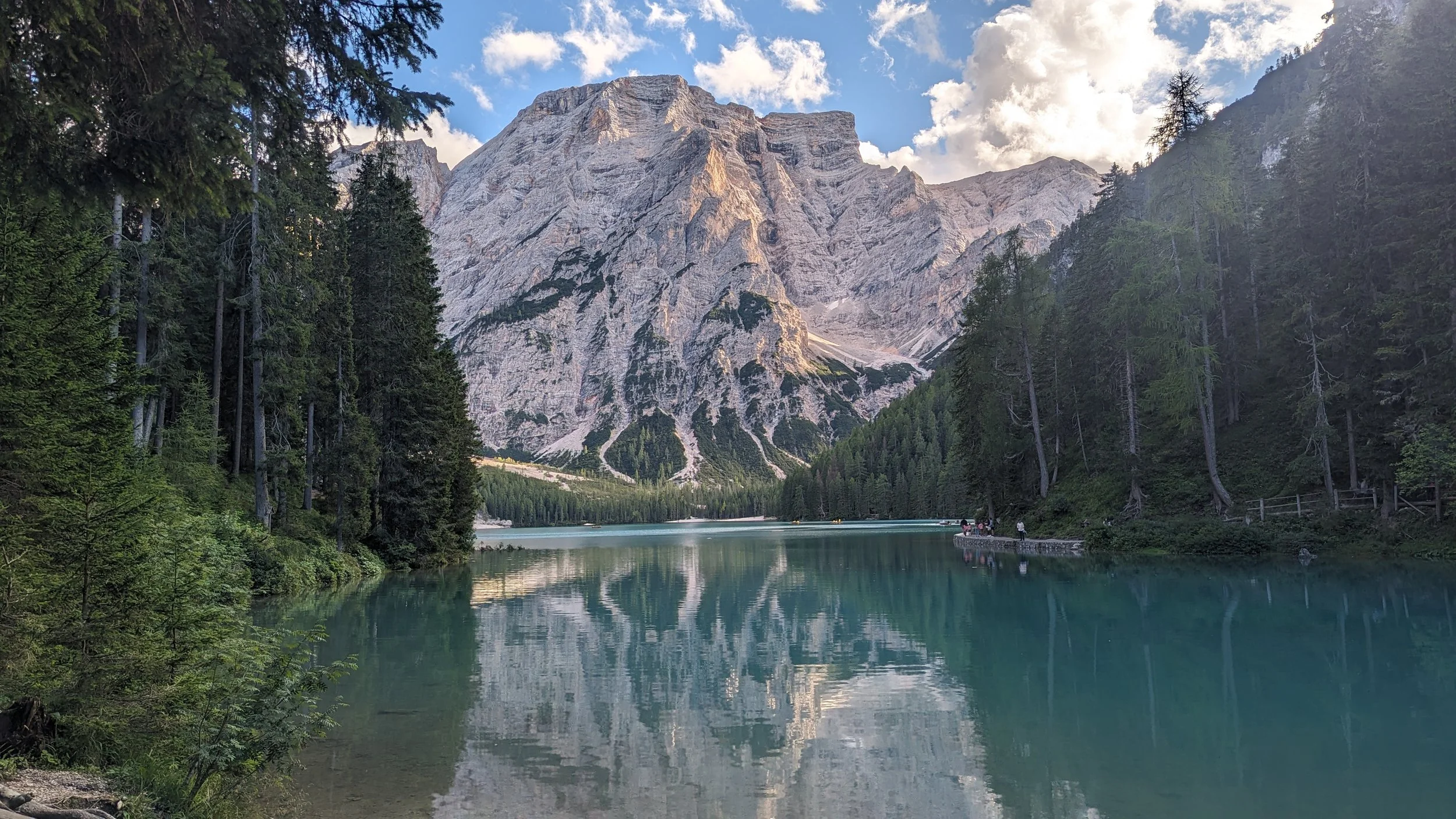
We had about an hour drive to our destination for the day which was Lago di Braies which is, a lot of vowels. It was immediately evident that this glacial lake is absolutely stunning. Maybe even more so than Lake Louise (which is hard to beat!)
But 'I’m someone who likes to work for my views, so I was never planning on just walking around the lake for some photos (though we did immediately start snapping pictures).

But we didn’t hang around for long - our mission was to hike the this route from Moon Honey Travel - Hochalpenkopf (Cima dei Colli Alti) Peak Hike.
I loved this hike. We marveled at the “ghost water” that was entirely translucent in streams and stopped to take in one of those views that makes you question whether or not you’re living in a simulation.

We dealt with some on and off showers but I loved frolicking my way through the Fojedöra High Alpine Pasture to perhaps my favorite hut of the trip! We found a dad in a kitchen with his child in a play pen, cooking up fresh, farm-grown food. After struggling through the entirely Italian and German menu, we had a delicious egg and potato scramble and unreal cheese plate (plus, cappuccino for me and a beer for Sam!) The sun came out as we ate and it was entirely magical.


The hike technically went further, but we decided to turn around since the weather was iffy and we wanted some time at the end to walk around Lago di Braies.
On the way back we got hit with some hail, but by the time we got back to the lake, it was beautiful out and perfect for a decent amount of photo taking. I’m SO glad we took the time (and energy) to hike to the Fojedöra hut and get more of an authentic experience in this region. Lago di Braies was next-level-beautiful, but we were enjoying it with a ton of other tourists. But, once you see the photos below, it’s really not shocking that there are tons of other people that want to take in these views!

On our final walk around the lake, we encountered an artist painting in the trees and I got a beautiful piece of art depicting Seceda! I love it in my apartment!
After finishing around 11 miles on our feet, we were ready to head back into town and get some foooooood! We ate and walked around Cortina D’Ampezzo (adorable town, pricy stores!) and obviously ended the evening with more gelato!
DAY 11 - TRE CIME DI LAVAREDO
The next day we got a little bit of a later start than anticipated on our way to hike the Tre Cime Di Lavaredo. I continued to be in awe of Sam’s bravery navigating the twists and turns and hills of the Cortina area. At one point, we made a tight turn and a giant tractor trailer truck came barreling towards us. We both screamed in terror and then started cackling with laughter in relief! Driving those roads felt like a physical and emotional roller coaster.

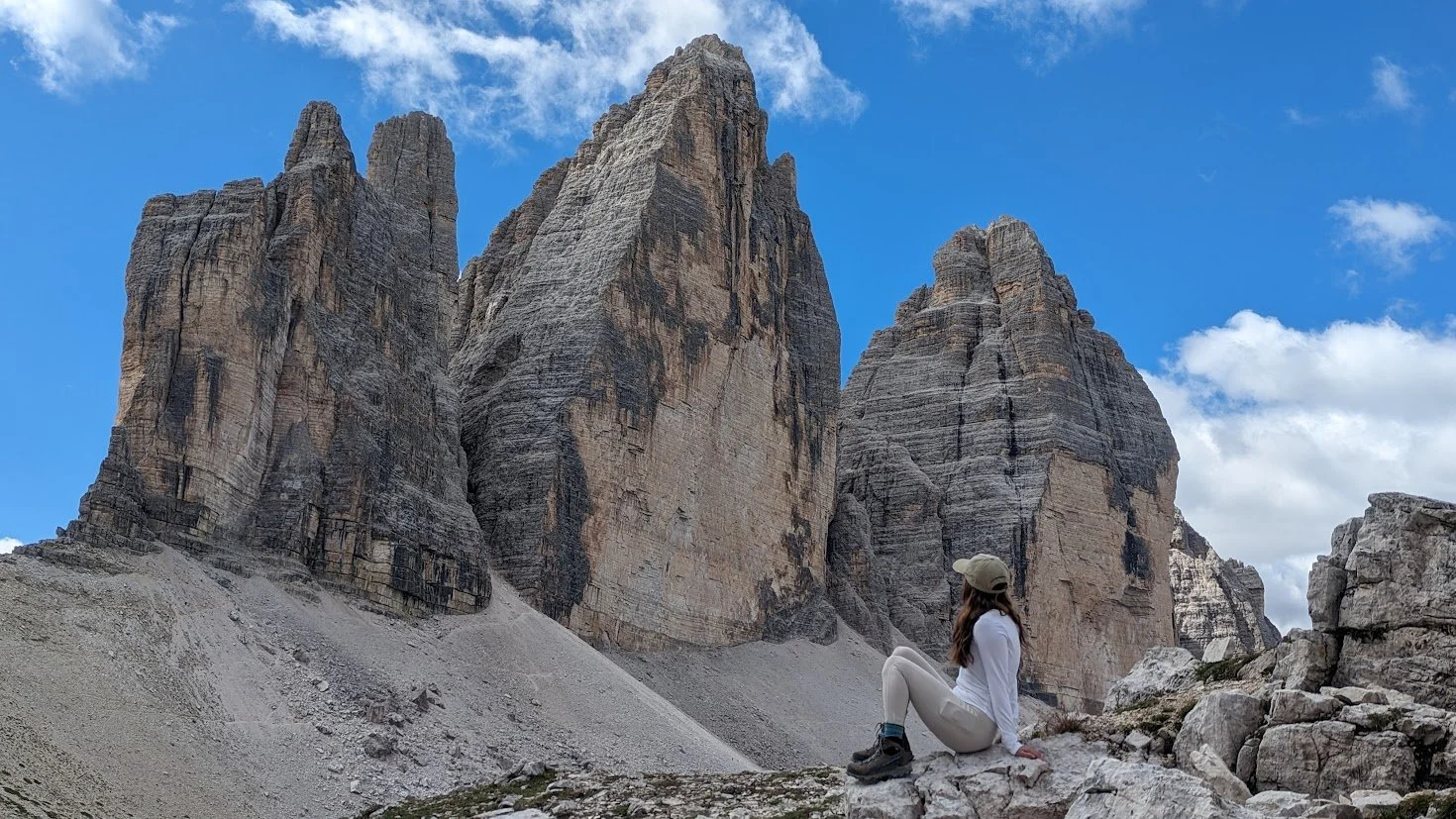
Tre Cime di Lavaredo is an incredibly popular day hike, so by the time we approached the main road, cars were being diverted to a parking lot where we had to wait in a pretty chaotic line to board shuttle buses to bring us up the toll road to Rifugio Auronzo where the hike starts.
Once we figured out the parking payment, the shuttle line, etc., we settled in for the ride up - it was gorgeous, and a beautifully sunny, but chilly morning!
Again, I highly recommend using Moon Honey Travels’ hiking guides - they have one specifically for the Tre Cime di Lavarado hike that you can find here. From Rifugio Auronzo you pick up trail 105, passing Forcella del Col del Medo until you hit another mountain hut - Langalm Alpine Hut- where you can stop for food and drinks (we kept going since it had only been about 45 minutes and the trail was already quite crowded).
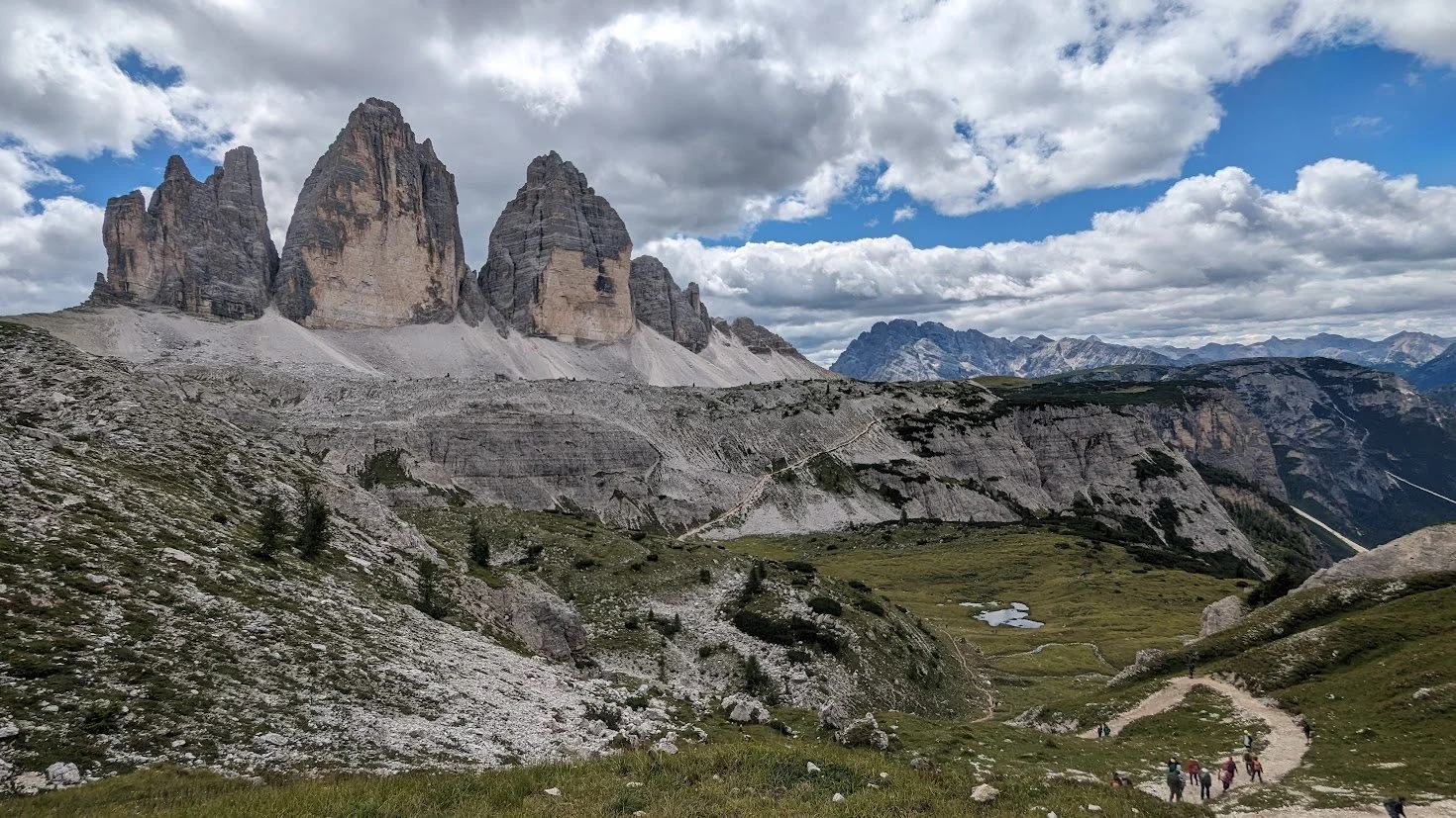
As we continued, the Three Peaks of Lavaredo came into view and they were iconic. We obviously had to stop for a full on photo shoot.
Following the photo shoot, we set our eyes on our lunch destination far off in the distance - Rifugio Locatelli/Drei Zinnen Hütte. From the first hut to Rifugio Locatelli is around an hour and 10 minutes.
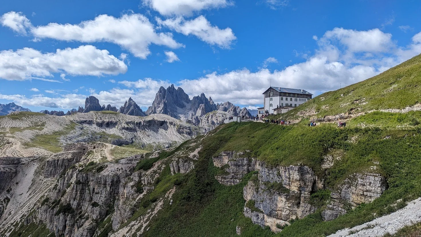
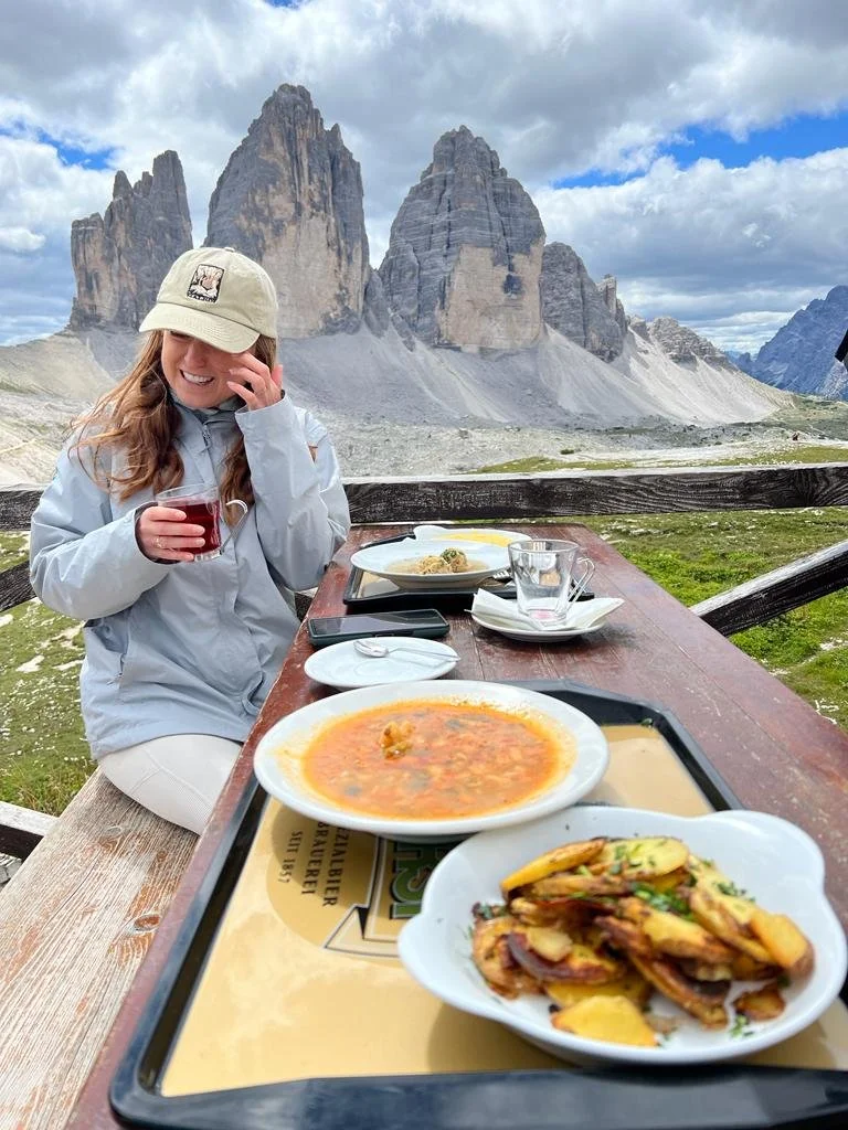
When we arrived at Rifugio Locatelli it was very busy but we managed to snag a table with an incredible view of the towers. It was COLD and windy and I had to steal a layer from Sam. The hut is self-service (go inside and order, there will not be a waiter coming around to tables) and CASH ONLY. We got some delicious (HOT) food and I also got a hot mulled wine. Continued to be impressed by the Dolomite mountain hut culinary experience!
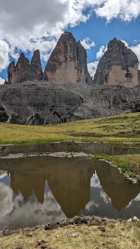
The trail continues past Laghu dei Piani lakes where I got this cool reflection photo even though the sun was momentarily absent.
The views were just absolutely amazing, and I didn’t even mind how crowded the trail was (though this back half of the loop is definitely less crowded than the first half!) The slower we went, the longer I had to enjoy the views of the Cadini range.
Following lunch is was probably about another hour and a half to two hours before we finished the loop, passing one final mountain hut, Malga Langalm with the most clear creek flowing by.
I can’t believe these views that simply don’t quit for the entirety of the hike!

Is this a popular and crowded hike? Yes. Do I understand why, and would I do it again? Yes. As long as you set your expectations, I think you’ll enjoy it!
Following our hike we ate pizza in town followed by gelato, of course!

FINAL THOUGHTS
I could not be happier that I chose to spend my first visit to Italy in the Dolomites. It is an incredibly beautiful place whose popularity is growing (and with the upcoming Winter Olympics, will likely continue to do so). This is a place I can see myself returning to time and again to see different areas, in different seasons, to eat different food and hike different hikes.
Now having done two hut to hut treks (TMB and the O-Loop in Patagonia), I am absolutely wanting to plan a hut-to-hut hike in the Dolomites. In my opinion, the views might be my favorite and the food certainly was!
How can you look at these photos and not want to explore the Dolomites??
Thanks for reading, and sorry for the 2 year delay on posting about this trip :)